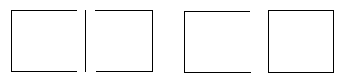
Digitize all polyline segments as indicated in the figure on
the left. The figure on the right will not work with the Create
Polygons by Locator command because it consists of a
polyline and a polygon.
The Draw | Edit Boundaries | Create Polygons by Locator command creates polygons from polylines.
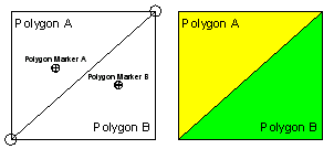
You can create polygons that share common borders by digitizing the shared border (polyline), and use the border to create both adjacent polygons. This command requires that a polygon marker be digitized somewhere within the polygon area to be created.
To create polygons using a locator marker:
Create all polyline segments by clicking the Draw | Polyline command. The segments should only be long enough to be shared by two polygons.
Digitize all polyline segments as indicated in the figure on
the left. The figure on the right will not work with the Create
Polygons by Locator command because it consists of a
polyline and a polygon.
Snap the polyline segments to one another by clicking the Draw | Edit Boundaries | Snap All Polyline Segments command. If the polyline segments are not snapping together, check the snap tolerance value and display the snap tolerance circles. You may need to reset the snap tolerance value or reshape the polyline.
Draw the polygon markers by clicking the Draw | Polygon Marker command.
Assign a Primary ID to each polygon marker in the Property Manager in the Data Attributes section.
Click the Draw | Edit Boundaries | Create Polygons by Locator command and the polygons are created.
Create all polyline segments, snap the polyline
segments, and draw the polygon markers
before using Draw | Edit Boundaries |
Create Polygons by Locator.
If a polygon is not created, check to be sure the polylines are snapped. If all polylines are snapped, try moving the polygon marker to a slightly different location within the polyline outlines. In some cases, moving the polygon marker to a slightly different location within the set of polylines allows the polygon to be created.
See Also