Specify the SHP file export options in the Export Options dialog.
The Export Options dialog, SHP Options page allows you to specify options which determine how information in the file is exported.
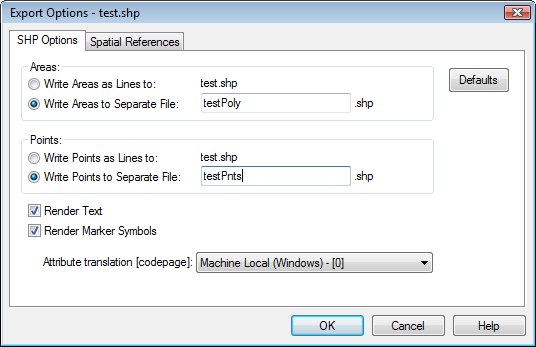
All attributes for all polyline, polygon, and symbol objects are automatically exported to all .SHP files.
Specify the SHP file export options in the Export Options dialog.
Note that an ESRI Shapefile (.SHP) file may contain either line objects, area objects, or point objects, but not a combination of different object types.
All objects can be written as line objects if the Write Areas as Lines and Write Points as Lines options are both selected, or either of the aforementioned controls may be selected individually to write only the corresponding objects as lines. Alternatively, areas and/or points can be written to separate files by selecting the Write Areas to Separate File and/or Write Points to Separate File controls, in which case valid file name(s) must be typed into the adjacent edit control(s).
By default, text is not output. Selecting the Render Text control will instead cause text to be rendered as lines and/or areas as appropriate. If this box is not checked, text will not be output as the .SHP format does not support text.
By default, marker symbols in the drawing are output as points. Selecting the Render Marker Symbols control will instead cause marker symbols to be rendered as lines and/or areas as appropriate.
By default, the “Western European (Windows)” code page (1252) will be used to translate 16-bit Unicode attribute text to 8-bit ANSI text stored in the companion .DBF file. This can be changed by selecting a different code page from the drop down list. This code page will be stored in a companion .CPG file and also in the .DBF file header. If characters from multiple languages are present, consider selecting “UTF-8 - [65001]”.
The Defaults button sets all options to default conditions.
The spatial reference information can be set on the Spatial References page. By default, if the map is in a defined coordinate system, the ESRI .PRJ and Golden Software .GSR2 files are automatically created for this ESRI file type.
See Also