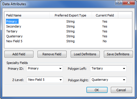
Click the Map | Data | Edit Attribute Fields command to open the Data Attributes dialog. This dialog lets you define new data fields (IDs) for objects. This command is particularly useful for preserving attributes from files that have been imported from different formats, like ESRI Shapefiles .SHP, AutoCad .DXF files, or files with Z values. This is also a useful command for deleting unnecessary attributes.
Set the ID columns in the Data Attributes dialog.
By default, the Data Attributes dialog includes the Primary, Secondary, Tertiary, and Quaternary IDs in the Field Name column. To change any field name, slow double-click (click once, wait a second, and click again) to edit the name. Type the new name and press ENTER on the keyboard to make the change.
Each field is defined as either String or Number under Preferred Export Type. The Current Field indicates whether the field is currently in use in the project. When importing files, up to 256 data fields can be preserved.
Click the Add Field button to add field names to the list. The new field name is listed as New Field and a number. The number indicates the field name. Since there are four fields, by default, the next field is named New Field 5.
Click the Remove Field button to delete the selected field from the project. If no field name is selected, Didger starts at the top of the list and removes the first item in the list of data fields.
Click the Load Definitions button to open the Open dialog. Select the Didger Data Attribute File (*.daf) that contains the field attributes and click Open. The DAF file is an ASCII data file that contains all of the field names and properties. After selecting the file and clicking Open, the field names appear in the Data Attributes dialog.
Click the Save Definitions button to open the Save As dialog. Type a File name to save the current field attribute settings to a Didger Data Attribute File (.daf). Click Save and the file is saved. This file can be used later to load definitions in this or another Didger project using the Load Definitions button.
The Specialty Fields section allows mapping of field names to one of the default fields defined in the Specialty Fields section. The Primary ID is used as the unique key for a data set. In most files, this will be the Primary field name. However, it could be any unique field in the project.
The Polygon Left and Polygon Right fields are used to store the left and right side IDs of the polygon boundary. These are used with the Draw | Edit Boundaries | Create Polygons by IDs command.
The Z-Level field is used to store elevation or production values. This column is primarily used with the Map | Surfer | Grid Data command. The Z-Level field must be defined before selecting this command.
See Also